Santo Antão, Cape Verde
From Cova to the Paúl Valley, a descent that measures Santo Antão
A short route on the map that descends from Cova’s cultivated crater to Cabo de Ribeira and shows why it is wiser to plan for elevation loss than simply count kilometres.
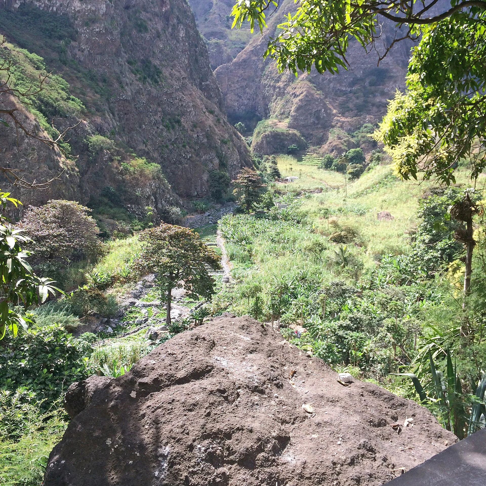
The route from Cova to Cabo de Ribeira captures an important choice on Santo Antão: accepting a sustained descent through a mountain agricultural landscape or choosing a shorter, steadier plan. This is not a hike to tick off a viewpoint; it is a way to understand how water, crops and local paths organise the Paúl Valley within an inhabited natural park.
A one-way route, not a round trip
The marked PR1 SAPL route begins at the Cova viewpoint and ends in Cabo de Ribeira. It covers 5.6 kilometres one way, with an estimated duration of two and a half hours. The figure may seem modest, but the starting point lies beside a high volcanic crater and the itinerary heads down towards the valley: think about the terrain, footwear and your personal tolerance for descents, not just the distance.
The best approach is to decide where the day will end before setting off. On reaching Cabo de Ribeira, you can finish the walk or continue through the valley; trying to improvise the return once tired leaves less room for decisions. Carry enough water, sun protection and a light layer for the changing exposure between the summit and the slopes.
Cova explains the origins; Paúl, the use of the landscape
Cova is more than a viewpoint. Its crater, slopes and high-altitude mists help explain a mountain moisture system that contrasts with other, drier parts of the island. From the rim, the descent opens up views over the Paúl Valley, where cultivated plots, vegetation and ravines form part of the same landscape.
The Cova, Paúl and Ribeira da Torre Natural Park brings together steep landforms, forested areas, biodiversity and agriculture. It is also a place where families live, and where paths, irrigation infrastructure and soil-protection techniques serve everyday purposes. The reward of the route is not simply reaching the bottom: it is observing the transition between crater, slope and an agricultural economy that continues to shape the land.
Walk attentively through a working landscape
The route crosses a lived-in landscape, not a rural backdrop. Stay on the path, do not cross fields to cut corners, and keep access points to homes, gardens and channels clear. If you want to photograph someone, a property or agricultural work up close, ask permission first.
Sugar cane, coffee, sweets, liqueurs and grogue are associated in the area with local knowledge of agricultural processing. Trying products made in the valley can be a sensible way to direct some of your travel spending locally, provided workshops and homes are not turned into intrusive attractions. Ask what is produced, how it is consumed and what stage of the working season the community is experiencing.
Reaching Santo Antão without treating the ferry as an afterthought
Santo Antão is connected by sea to São Vicente, so the walk really begins when you organise the crossing to Porto Novo. The journey can fit well into a trip of several days if you leave enough time between arriving on the island, reaching the trailhead and making your onward departure.
Timetables, frequencies, boarding conditions, ticket changes and assistance for passengers with reduced mobility are operational details: check them directly with the ferry operator before buying flights, booking accommodation or fixing your walking day. For this one-way route, also confirm with your accommodation or a local provider how you will get to the start and leave the valley afterwards.
Who this descent suits
Cova–Cabo de Ribeira suits anyone looking for a half-day walk who accepts that its appeal lies in the elevation change and reading of the terrain, not in collecting summits. It also works as a first introduction to Santo Antão if you later want to choose more deliberately between other coastal routes, valleys or more demanding trails.
It is not the most comfortable choice for anyone who needs an accessible route, even surfaces or a guaranteed return to the same point. In that case, it is better to visit Cova as a viewpoint and build a day around pre-arranged transport. Checking the trail’s recent condition is especially important after rain, works or local changes.
Sources to check before setting out
Rutas de Santo Antão / ADPM: the PR1 SAPL route information sheet, to verify the trail alignment, length, estimated duration and current condition.
Instituto do Património Cultural de Cabo Verde: background on the Cova, Paúl and Ribeira da Torre Natural Park, its resident communities and its agricultural, environmental and cultural values.
Nôs Ferry: current timetables, tickets, boarding requirements and reduced-mobility assistance for the São Vicente–Santo Antão connection. Check these details immediately before travelling: they are the elements most likely to change.
References consulted during editorial review. Times, requirements and advisories may change: always confirm with the official source.
- https://visitsantoantao.net/en/experiences/routes/ visitsantoantao.net
- https://www.santoantao-tour.com/english/santo-antao/tours/ www.santoantao-tour.com
- https://www.visit-caboverde.com/en/islands/santo-antao-island www.visit-caboverde.com
- https://gocaboverde.cv/en/santo-antao gocaboverde.cv
- https://visitsantoantao.net/fr/portfolio-item/route-de-la-vallee-pr1-sapl/ visitsantoantao.net
- https://ipc.cv/monumento-e-sitio/parque-natural-de-cova-paul-e-ribeira-da-torre-pncprt/ ipc.cv
- https://cabo-verde.cv/hiking-vale-de-paul-santo-antaos-lush-green-heart/ cabo-verde.cv
- https://destinationcapeverde.com/hike-from-the-cova-volcano-crater-to-ribeira-paul/ destinationcapeverde.com
- Cabo Verde WikidataCC0 1.0 Wikidata · Q1011
- Cabo Verde WikidataCC0 1.0 Wikidata · Q5015739
- Cabo Verde WikidataCC0 1.0 Wikidata · Q216889
- Cabo Verde WikidataCC0 1.0 Wikidata · Q61240463
- Cabo Verde WikidataCC0 1.0 Wikidata · Q34826012
- Cabo Verde WikidataCC0 1.0 Wikidata · Q125230885
- Cape Verde World Countries — mledozeODbL 1.0 World countries dataset by mledoze and contributors · ODbL 1.0
- Cabo Verde World Bank Open DataCC BY 4.0 World Bank
- Cape Verde DBpediaCC BY-SA 3.0 DBpedia
- Turismo e desenvolvimento dos territórios insulares: apontamentos para uma geografia do turismo de Cabo Verde CrossrefMetadatos públicos; derechos específicos por campo cuando correspondan Crossref
- Table 5.5 Cabo Verde / Cabo Verde CrossrefMetadatos públicos; derechos específicos por campo cuando correspondan Crossref
- Table 4.1 Cabo Verde / Cabo Verde CrossrefMetadatos públicos; derechos específicos por campo cuando correspondan Crossref
- A complexa equação Segurança, Turismo e Desenvolvimento Sustentável em Cabo Verde CrossrefMetadatos públicos; derechos específicos por campo cuando correspondan Crossref
- Cabo Verde CrossrefMetadatos públicos; derechos específicos por campo cuando correspondan Crossref
- Santo Antão GeoNamesDatos geográficos bajo CC BY 4.0; requiere atribución a GeoNames. Fuente: GeoNames
- Santo Antão, Porto Novo, Cape Verde OpenStreetMapODbL 1.0; atribución y obligación de compartir bases derivadas. Fuente: OpenStreetMap