Mexico City, Mexico
Walking Mexico City’s Ciudad Universitaria from Rectoría to the Stadium
A day across UNAM’s Central Campus, linking modern architecture, muralism and the volcanic landscape that shaped the city’s southern reaches.
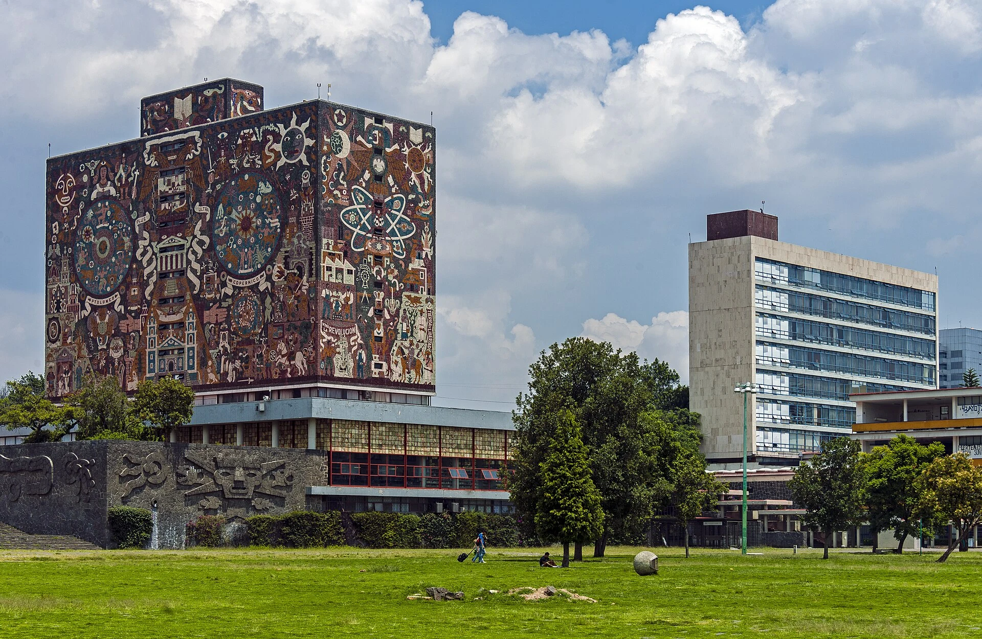
Ciudad Universitaria is not a monumental precinct set apart from the city: it is a working university, shaped by classes, research, sport and everyday journeys. That is the best key to visiting it. The Central Campus brings together an exceptional integration of architecture, art and open space on the former lava fields of Pedregal; taking time to explore it reveals the murals as part of an urban project, rather than isolated backdrops for photographs.
The plan fits into an unhurried day without a car. Choose a short route—Rectoría, the Central Library and the Olympic Stadium—then add the Botanical Garden or MUAC, depending on whether you are more interested in living landscapes or contemporary art.
A campus that is still a university
The value of the Central Campus lies in the relationship between its buildings, plazas and uses. Built between 1949 and 1952 by a large team of architects, engineers and artists, the complex was conceived as a work of modern urbanism incorporating references to the pre-Hispanic past and the site’s volcanic foundation.
That is why an attentive visit begins by looking at distances: the plaza in front of Rectoría, the prism-shaped silhouette of the Central Library and the semi-buried volume of the Olympic Stadium do not function as independent monuments. Together, they form a sequence of public and academic spaces. Keep entrances, ramps, corridors and classroom areas clear; visiting without interrupting is part of understanding a heritage site that is still in use.
The essential route from Rectoría to the Stadium
Start at the Rectoría plaza and view David Alfaro Siqueiros’s murals from several angles: the reliefs were designed to be read in motion and from a distance. From there, continue to the Central Library. Juan O’Gorman’s stone mosaic covers all four façades and changes radically depending on which side you see it from; do not try to take it all in at once.
Continue to the Olympic Stadium to view Diego Rivera’s relief on the eastern façade from outside. This part of the route is fairly compact, but it is not a quick one: pause at the transitions between plazas, gardens and buildings. The interest lies as much in the composition of the whole as in the recognizable artworks.
Two possible endings for the same day
If you want to extend the visit into the world of botany, choose the Botanical Garden of the Institute of Biology. Its living collections make it possible to recognize Mexican plants on a campus built over a lava landscape. It is a good extension for anyone who prefers to slow down and move from monumental scale to observing plant species and forms.
If you are more interested in contemporary art, take the internal shuttle to the Cultural Zone and set aside time for MUAC. Its programme changes, so it is best not to build the whole day around a particular exhibition without checking it beforehand. Choosing between the garden and the museum prevents an overpacked schedule: both complement the campus, but they suit different rhythms.
Getting around without a car and pacing the walk
Universidad Metro station and Ciudad Universitaria Metrobús station connect with the internal Pumabús system. This free service is available to visitors and is especially useful for linking public-transport access with the Botanical Garden, the Cultural Zone or the return from areas farther from the Central Campus.
For the Rectoría–Library–Stadium sequence, walking helps you perceive the spatial relationships; for the rest of the campus, combine walking stretches with the bus. Bring water, sun protection and stable footwear: there are broad plazas and exposed routes. Service conditions, active routes and timetables may change during university holidays or special events; check them on the day.
What to avoid so the visit makes sense
Do not treat Ciudad Universitaria as a collection of façades to tick off in an hour. Make fewer stops, listen to your surroundings and pay attention to who uses each space. The murals, libraries, sports courts and green areas belong to a living public institution, with academic and cultural work taking place every day.
It is also worth distinguishing the listed heritage site from the rest of the enormous Ciudad Universitaria. The Central Campus is the core recognized for its historic design; the Botanical Garden and Cultural Zone broaden the experience, but they do not replace reading that original layout. Fewer journeys and more observation generally make for a clearer and more respectful visit.
Official references to check before going
- UNESCO World Heritage Centre: listing and map of UNAM’s Central Campus of Ciudad Universitaria, inscribed in 2007.
- UNAM General Directorate of General Services and Mobility: current Pumabús routes and operations.
- Mexico City Metro system: information for Universidad station on Line 3.
- UNAM Institute of Biology: access to the Botanical Garden from Universidad Metro, Ciudad Universitaria Metrobús and Pumabús.
- Museo Universitario Arte Contemporáneo: current programme, opening hours, prices and access conditions.
Check before setting out transport timetables, venue openings, exhibitions, access arrangements and any changes caused by the university calendar.
References consulted during editorial review. Times, requirements and advisories may change: always confirm with the official source.
- https://www.dgsgm.unam.mx/pumabus.html www.dgsgm.unam.mx
- https://whc.unesco.org/en/list/986 whc.unesco.org
- https://whc.unesco.org/uploads/nominations/1250.pdf whc.unesco.org
- https://accionmigrante.unam.mx/contacto/ accionmigrante.unam.mx
- https://iibi.unam.mx/CIIBI2019/images/docs/PumabusRutas.pdf iibi.unam.mx
- https://www.ib.unam.mx/ib/jb/como-llegar/ www.ib.unam.mx
- https://www.dgeci.unam.mx/es/blog/mapas www.dgeci.unam.mx
- https://whc.unesco.org/en/tentativelists/5759 whc.unesco.org
- México WikidataCC0 1.0 Wikidata · Q96
- México WikidataCC0 1.0 Wikidata · Q55712
- Mexico World Countries — mledozeODbL 1.0 World countries dataset by mledoze and contributors · ODbL 1.0
- Mexico World Bank Open DataCC BY 4.0 World Bank
- Mexico DBpediaCC BY-SA 3.0 DBpedia
- Las territorialidades del turismo: el caso de los Pueblos Mágicos en México OpenAlexCC0 1.0 OpenAlex
- Turismo rural comunitario en México: apuntes para futuras investigaciones OpenAlexCC0 1.0 OpenAlex
- Sostenibilidad del turismo y planeación municipal en México CrossrefMetadatos públicos; derechos específicos por campo cuando correspondan Crossref
- Turismo en pueblos mágicos de México. Impactos y retos rumbo a la sostenibilidad CrossrefMetadatos públicos; derechos específicos por campo cuando correspondan Crossref
- Sostenibilidad del turismo y política pública: consideraciones desde la seguridad ciudadana y limpieza en pueblos mágicos de chiapas CrossrefMetadatos públicos; derechos específicos por campo cuando correspondan Crossref
- Sostenibilidad y comunidad: El éxito de gestión de la Cooperativa Tosepan Kali en el Pueblo Mágico de Cuetzalan, Puebla CrossrefMetadatos públicos; derechos específicos por campo cuando correspondan Crossref
- Rafael Lemus, Breve historia de nuestro neoliberalismo. Poder y cultura en México. México: Debate, 2021, 231 p. CrossrefMetadatos públicos; derechos específicos por campo cuando correspondan Crossref
- La competitividad turística ante los retos de sostenibilidad en los pueblos mágicos, análisis de santiago, nuevo león CrossrefMetadatos públicos; derechos específicos por campo cuando correspondan Crossref
- Relaciones causales: gentrificación y sobreturismo, un estudio comparativo en dos pueblos mágicos de puebla, méxico CrossrefMetadatos públicos; derechos específicos por campo cuando correspondan Crossref
- Ciudad Universitaria GeoNamesDatos geográficos bajo CC BY 4.0; requiere atribución a GeoNames. Fuente: GeoNames
- Ciudad Universitaria, Mexico City, 04360, Mexico OpenStreetMapODbL 1.0; atribución y obligación de compartir bases derivadas. Fuente: OpenStreetMap